California Lost: Coachella
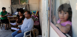
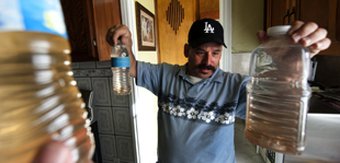
In the heat of the desert, more than 30,000 farmworkers have set up makeshift homes in overcrowded trailer parks – often without access to clean water, electricity and sewage systems. Some, like Ana Sanchez, are demanding basic rights to safe living conditions.
I shot and edited this multimedia profile, part of a series I produced for the Center for Investigative Reporting called California Lost. The video appeared on The Huffington Post, New America Media, KPCC.org, the SF Chronicle’s iPad app, Mun2 (NBCUniversal’s LA network for Latinos), and several blogs. I also produced a Spanish-language version of the video. Read the print feature by Patti Leigh Brown and learn more about the story.


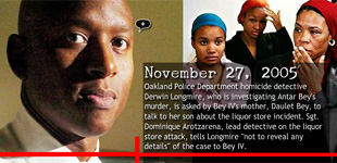
 I designed this interactive timeline for The Chauncey Bailey Project using Vuvox.com. It accompanied an Oakland Tribune story reporting that Sgt. Derwin Longmire, the lead detective assigned to investigate journalist Chauncey Bailey’s 2007 shooting, had many ties to Your Black Muslim Bakery—and several members of the bakery were suspects in Bailey’s murder. Reporters discovered Longmire had been presented with evidence that Yusuf Bey IV, the bakery CEO, was likely involved in the murder, but the detective failed to document that evidence in the case file. This timeline tracked Longmire’s many connections to the Bey family.
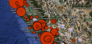
 This map, produced for California Watch, shows the top 100 carbon dioxide-producing facilities in the state, according to data released by the California Air Resources Board. Power plants and oil refineries appear to be the largest culprits. I researched and mapped the individual facilities on a Google satellite image using Mapbuilder.net. I designed custom markers to visually show the amount of carbon dioxide emissions from each facility, and calculated conversions to demonstrate the scale and impact of those emissions.